
Area guidesBlackheath
Blackheath
SE3 · Lewisham
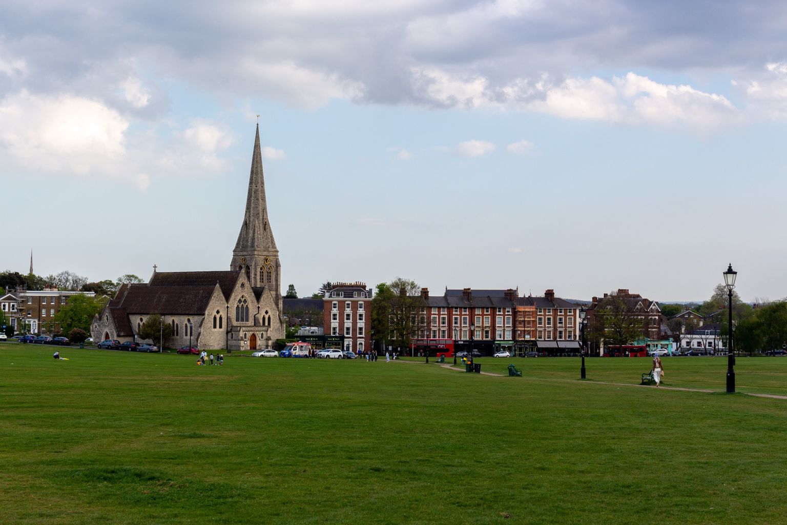
All Saints' Church standing on the heath, with Blackheath village behind. Photograph by The wub.
Blackheath sits where a wide, wind-scoured common gives way to a tight cluster of Georgian streets, and that contrast is most of its character: an open heath used for kite flying, marathon starts and the odd fairground, ringed by a village-scaled centre of independent shops, cafes and music venues. It reads as a self-contained small town that happens to sit on the edge of London, with Greenwich Park and the river close by but not on the doorstep.
What stands out
- A proper village core around Blackheath station — independent shops, cafes and music venues (the Conservatoire, Blackheath Halls) within walking distance of the heath itself.
- An unusually deep sporting pedigree: golf's first English foothold, one of the world's oldest rugby clubs, and the modern London Marathon all trace a start line to this heath.
- Strong, visible community traditions — kite flying on the heath, the On Blackheath festival, and a historic Guy Fawkes fireworks night — that give the calendar a rhythm beyond the shops.
Trade-offs
- The heath is the area's best feature and its most exposed: a walk across it has no shelter from wind or rain, unlike a park with tree cover.
- The Village shopping cluster is compact by design; anyone wanting a big supermarket or wide retail choice will look beyond it.
- Some long-running fixtures have proved fragile — the Guy Fawkes fireworks lost funding and were suspended, a reminder that traditions here depend on continued sponsorship, not just custom.
Things to know about Blackheath
- The On Blackheath music festival returned to the heath in 2025 after a pandemic-era hiatus, having previously drawn headliners including Massive Attack, Grace Jones, Madness and The Libertines.
- The London Marathon starts here, on the heath alongside Greenwich Park.
- Entrepreneur Richard Branson and fashion designer Mary Quant were both born in Blackheath.
- Blackheath Rugby Club, one of the oldest documented rugby clubs in the world, staged the world's first rugby international in 1871 — one of several sporting 'firsts' tied to the heath, alongside golf's traditional introduction to England here in 1608.
- Suffragette Emily Davison was born in Blackheath.
Life here
- Two shopping and leisure clusters serve the area: the 'Village' around Blackheath railway station, and the 'Standard' north of the A2 near Vanbrugh Park.
- The Blackheath Conservatoire of Music and the Arts and Blackheath Halls (now run by Trinity Laban Conservatoire of Music and Dance) anchor a live-music and arts scene near the station.
- All Saints' Parish Hall, an Arts and Crafts building of 1928 in Tranquil Vale, has housed the Mary Evans Picture Library since 1988.
- Kite flying has a long history on the heath, and the Blackheath and Bromley Harriers athletics club traces its roots to the Blackheath Harriers, founded in 1869.
- The historic Guy Fawkes fireworks display on the heath was suspended after Greenwich Council withdrew funding in 2010, then further disrupted by the pandemic and government funding cuts.
History and what it is known for
- The name is recorded in 1166 as 'Blachehedfeld', Old English for 'dark, or black, heath field' — a name about soil or bleak exposure, not (despite a persistent local myth) a reference to the Black Death or the 1665 plague.
- Blackheath was a rallying point for Wat Tyler's Peasants' Revolt in 1381 and Jack Cade's Kentish rebellion in 1450; Cornish rebels were defeated nearby at the Battle of Deptford Bridge, sometimes called the Battle of Blackheath, in 1497.
- Henry IV met the Byzantine Emperor Manuel II Palaiologos here in 1400, and in 1415 the Lord Mayor of London led citizens here in procession to greet Henry V returning from the Battle of Agincourt.
- The heath was a notorious haunt of highwaymen in the 17th and 18th centuries, with gibbets once a feature of the landscape.
- In 1608, tradition holds that golf was introduced to England at Blackheath; Blackheath was also a founding member of the Football Association in 1863, and Blackheath Rugby Club (founded 1858) organised the world's first rugby international, England v Scotland, in 1871.
- The Vanbrugh Pits, former gravel workings on the heath's north-east, are named for their proximity to Vanbrugh Park; the heath's freehold and gravel rights trace back to the Earl of Dartmouth's manorial ownership, with management passing through the Metropolitan Board of Works, London County Council and Greater London Council before splitting between Greenwich and Lewisham councils in 1986.
Notable connections
- Richard Branson — Entrepreneur and businessperson, born in Blackheath.
- Mary Quant — Fashion designer, born in Blackheath.
- Emily Davison — Suffragette and women's rights activist, born in Blackheath.
- Vanessa Redgrave — Actor and director, born in Blackheath.
- Sarita Choudhury — Film and television actor, born in Blackheath.
- Clemence Dane — Novelist, playwright and screenwriter, born in Blackheath.
Background from Blackheath, London on Wikipedia (CC BY-SA 4.0) and Wikidata (CC0), summarised for this guide. Details change — check anything that matters to you.
Everyday life
A Saturday here tends to start in the Village around Blackheath station — coffee and browsing among the independent shops of Tranquil Vale and the surrounding streets — before a walk out onto the heath itself, past the Vanbrugh Pits or towards Greenwich Park, and on to the second cluster of shops and pubs at the Standard to the north. Evenings can mean a concert at Blackheath Halls or the Conservatoire, or a pub in one of the two village hubs. Community life leans on long-standing institutions rather than novelty: kite flying on the heath is a genuinely old habit, the Blackheath and Bromley Harriers (founded in the nineteenth century as the Blackheath Harriers) still run from here, and the On Blackheath music festival, which paused for several years, returned to the heath in 2025. The historic Guy Fawkes fireworks display is a reminder that not every tradition survives funding cuts intact — it was suspended after councils withdrew support and the pandemic closed the gap further.
Housing character
Housing character splits along the heath's edges. To the south-east, the Cator Estate (Blackheath Park) is built around large Georgian and Victorian houses, most strikingly Michael Searles' colonnaded crescent, the Paragon, alongside later twentieth-century Span-designed houses and flats set in their own gardens. Elsewhere around the heath, red-brick Georgian and Victorian villas and terraces predominate, several with direct historical ties to the aristocratic estates that once bordered the common. It is a place of period property and conservation-area streets rather than new-build blocks, and buyers should expect the character — and the listing restrictions that come with it — to shape what can be altered.
Getting around
Blackheath railway station sits at the heart of the Village, with Westcombe Park station serving the northern Vanbrugh Park end of the area. The A2 runs along the northern edge, separating the Standard cluster from the heath and the Village to the south. The heath itself is the area's main open space for walking and cycling, doubling as a route towards Greenwich Park. As with any London-edge location, actual travel times into central London or elsewhere are worth checking directly against live timetables rather than assumed from distance alone.
Things to investigate
Our figures here are borough-level, not neighbourhood-level: the house-price series is a Lewisham-wide ONS average, not a Blackheath median, and no rent series or journey-time data is connected at all, so treat any of those claims elsewhere with caution. School counts are drawn from a straight-line radius around a reference point, not from catchment or admissions data, so check the current admission authority for any specific school before assuming eligibility. The boundary used throughout is the SE3 postcode district, a proxy for the historic village rather than an approved neighbourhood polygon, and it straddles the Greenwich/Lewisham boundary, so some sources describing 'Blackheath' cover a different footprint than ours.
Schools
Measured by distance from the area centre, straight line. Primary is a walk and secondary is a journey, so they are counted on different radii. Ofsted's published judgements, not a Greathome rating.
Primarystate-funded, within 2 km
21 schools
- Judged by Ofsted
- 20
- At least Good
- 19
- Outstanding or equivalent
- 5
- Below Good
- 1
Secondarystate-funded, within 5 km
23 schools
- Judged by Ofsted
- 20
- At least Good
- 19
- Outstanding or equivalent
- 8
- Below Good
- 1
32 open schools of every phase sit within 2 km, 5 of them independent. Independent schools carry no Ofsted judgement in this release, so they appear in the total and never in the judged figures. Nothing here establishes catchment, admissions eligibility or available places.
The nearest 6 schools, with their published judgement
| School | Phase | Distance | Published judgement |
|---|---|---|---|
| All Saints' Church of England Primary School Blackheath | Primary | 0.3 km | Good · Overall effectiveness, pre-September 2024 |
| John Ball Primary School | Primary | 0.5 km | Outstanding · Overall effectiveness, pre-September 2024 |
| St Matthew Academy | All-through | 0.5 km | Requires improvement · Overall effectiveness, pre-September 2024 |
| Christ The King Sixth Form College | 16 plus | 0.6 km | No published judgement |
| Heath House Preparatory School | Not applicable | 0.7 km | No published judgement |
| St Ursula's Convent School | Secondary | 0.8 km | Expected standard · Report card, curriculum and teaching |
Housing market context
£491,259average house price across Lewisham, June 2026
A year earlier the same measure was £488,561, a change of +0.6%.
Average price across the whole local authority for one month, from the ONS series built on HM Land Registry UK House Price Index data. It is not a neighbourhood median and not a valuation of any property. Two guides in the same borough share this figure while their streets differ. House-price data is revised, and recent months are the most likely to move.
Source: Average house price by local authority, Office for National Statistics, from HM Land Registry UK House Price Index.
Boundary
Blackheath, taken as the SE3 postcode district. A postcode-district proxy, not an approved polygon. These are postcode districts standing in for an approved polygon. Present every count as "in these postcode districts", never as a neighbourhood or town-centre figure.
Sources
- Average house price by local authority — Office for National Statistics, from HM Land Registry UK House Price Index
- Get Information About Schools — Department for Education
- Ofsted inspection management information — Ofsted
- Street-level crime data — Police.uk
- Postcode and administrative geography — Postcodes.io / ONS
Evidence checked 2026-09-13. Last content change 2026-09-13. Next review 2026-09-20.
What is already known about Blackheath
Geography from the official record. A district or place name is a group of postcodes, not one address.
- Live postcodes
- 795 in SE3
- Localities
- Blackheath, Blackheath Westcombe, Charlton Hornfair, Eltham Page
- Local authority
- Greenwich, Lewisham
- Country
- England
- Centre postcode
- SE3 0AB
The pin uses Postcodes.io coordinates, not an exact entrance or title boundary.
Districts next to SE3
Found in the same 2.8 km sample around the centre of SE3, from 225 live postcodes. Proximity, not a boundary.
- SE7Greenwich Peninsula · Charlton Hornfair · Charlton Village & Riverside31 postcodes in the sample
- SE13Blackheath · Lee Green28 postcodes in the sample
- SE12Middle Park & Horn Park · Kidbrooke Village & Sutcliffe · Lee Green26 postcodes in the sample
- SE9Eltham Page24 postcodes in the sample
- SE10East Greenwich · Blackheath Westcombe · Greenwich Park11 postcodes in the sample
- SE18Kidbrooke Park3 postcodes in the sample
Nearby pubs
Pubs mapped in OpenStreetMap within 2.0 miles of SE3 0QR, nearest first.
Loading nearby pubs…
Place data from OpenStreetMap, available under the Open Database Licence (ODbL). © OpenStreetMap contributors
Look this place up in detail
Each of these opens on SE3 0QR, the postcode anchoring Blackheath, and queries its own source only when you open it.
Geography and local records
Local records load separately while you read the guide.
What this report does not cover
- neighbourhood median sale price (not_available): Only a local-authority average is connected, from ONS. A neighbourhood median needs enough geocoded transactions inside the guide boundary, which the per-postcode HMLR queries cannot supply.
- rents (not_available): No rent series is connected. Advertised rents and official all-tenancy measures are different things and neither is available here yet.
- journey times (not_available): No journey planner is connected. Transport is measured as nearby stops, not as time to anywhere. TfL PTAL and journey-time APIs would replace it for London.
- school admissions history (not_available): Admission arrangements are held by each admission authority and are not in the GIAS or Ofsted snapshots.
- licensed premises and venues (not_available): No licensing register or venue dataset is connected. Food-hygiene categories are not a pub register.
- image rights (not_yet_verified): No licensed image library is connected. Return an image brief rather than an asset.
- approved boundary polygon (not_yet_verified): Boundaries are postcode-district proxies. Counts describe the districts named, not a town-centre polygon.