Greathome

greathome.uk is a non-profit portal providing independent information about UK property to support buyers, sellers, and renters. Unaffiliated with any commercial company, the site is created and sponsored by Brandflame.co.uk

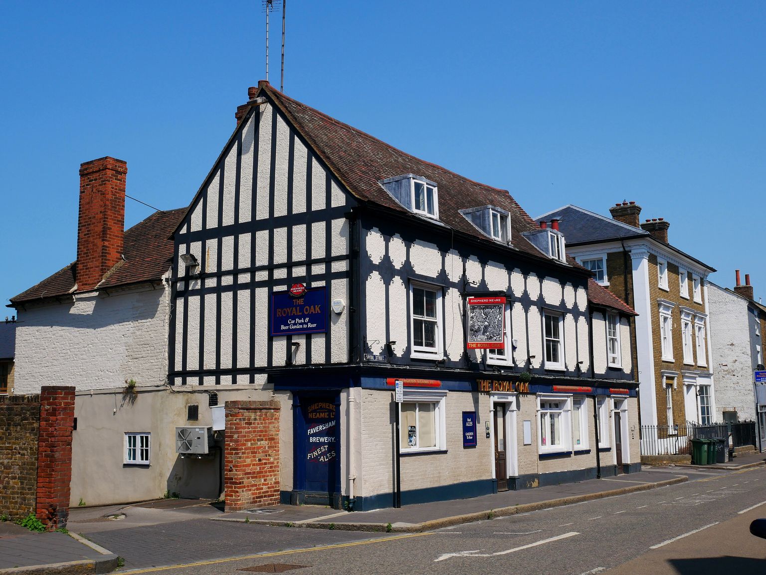
The timber-framed Royal Oak public house, Dartford

Area guidesDartford

Dartford

DA1 · Dartford, Kent

Maintained area report

Read another area

The timber-framed Royal Oak public house, Dartford. Photograph by Ethan Doyle White.

Dartford sits where the old Dover road crosses the River Darent, on the Kent bank of the Thames just beyond London's south-east fringe. It is a working market town with a long industrial memory — paper, engineering and amplifiers all trace back to workshops here — now rebuilding its centre around new housing, a revived theatre and easy rail links into the capital. For newcomers it offers a town-centre pace rather than a suburban one, with the countryside of the Darent Valley close at hand and the Thames crossings a short drive north.

What stands out

  • A genuine market-town core with a long, traceable industrial history — from an early English paper mill to the engineering works that became J & E Hall and the amplifier maker Vox — rather than a purely commuter-dormitory feel.
  • Central Park and the Orchard Theatre anchor community life in the town centre, alongside a spread of long-running football, rugby, athletics and triathlon clubs that give residents an easy way into local sport.
  • A strong pull for London-facing commuters and newcomers weighing Kent against south-east London, given the town's position just outside the capital on the Thames-side road and rail corridor.

Trade-offs

  • The historic High Street and older shopping centres have struggled for years against out-of-town retail, and parts of the centre are still mid-regeneration rather than finished.
  • Dartford's identity is entangled with its neighbours — the DA1 postcode district crosses into Bexley, so what counts as "Dartford" on paper is wider than the town centre itself.
  • The area's industrial past has left a legacy of former quarry and works land that has needed remediation and redevelopment, and some of that work is ongoing.
Postcode districtsDA1outcode-proxy-v1 · Greathome editorial boundary proxy
Local authorityDartfordCurrent · ONS Postcode Directory via Postcodes.io

Things to know about Dartford

  • Mick Jagger and Keith Richards, founding members of The Rolling Stones, were both born in Dartford.
  • Richard Trevithick, the pioneering steam-locomotive engineer, died in Dartford.
  • In 1545, Henry VIII held a series of Privy Council meetings in Dartford, briefly making the town the seat of national government.

Life here

  • The Orchard Theatre in the town centre stages drama, dance, music and other touring entertainment.
  • The Mick Jagger Centre, on the grounds of Dartford Grammar School, provides facilities for community arts.
  • Central Park in the town centre is used for community events and is home to Dartford Harriers Athletic Club, founded in 1922.
  • Dartford F.C. play at Princes Park Stadium in the Isthmian League, alongside other local clubs including Fleetdown United, Kent United and Halls AFC.
  • Dartfordians Rugby Football Club and the Dartford and White Oak Triathlon Club, one of the oldest British Triathlon Federation clubs in the UK, are both based in the town.

History and what it is known for

  • The Dartford area has evidence of human occupation stretching back around 250,000 years, associated with the prehistoric Swanscombe Man finds nearby.
  • In the medieval period Dartford was a waypoint for pilgrims travelling to Canterbury, and the Knights Templar held the manor in the 12th century.
  • Dartford was a key gathering point early in the 1381 Peasants' Revolt, with Kentish and Essex rebels assembling in the town before marching on Rochester and Canterbury.
  • Henry V marched through Dartford in 1415 after Agincourt, and in 1452 Richard, Duke of York camped near the town before surrendering to Henry VI.
  • Henry VIII had the town's priory destroyed in 1538 and built a new manor house; his fourth wife, Anne of Cleves, later lived there for four years until her death in 1557.
  • Protestant martyrs, including linen-weaver Christopher Wade, were burned at the stake in Dartford during the reigns of Mary I; they are commemorated by the Martyrs' Memorial on East Hill.

Notable connections

  • Mick Jagger — Rolling Stones singer-songwriter, born in Dartford.
  • Keith Richards — Rolling Stones guitarist and songwriter, born in Dartford.
  • Peter Blake — Pop artist, born in Dartford.
  • Richard Trevithick — Inventor and mining engineer, pioneer of steam locomotion, died in Dartford.
  • Margaret Thatcher — Later Prime Minister; unsuccessfully stood as parliamentary candidate for Dartford in 1950 and 1951.
  • Bernie Ecclestone — Former Formula 1 CEO, who lived in Dartford for most of his childhood and early adult life and attended Dartford West Secondary School.

Background from Dartford on Wikipedia (CC BY-SA 4.0) and Wikidata (CC0), summarised for this guide. Details change — check anything that matters to you.

Everyday life

Daily life centres on the town core: the Orchard Theatre hosts touring drama, dance and music, Central Park is the venue for community events, and the Mick Jagger Centre at Dartford Grammar School provides further space for community arts. Sport is well represented locally, with Dartford F.C. at Princes Park Stadium, Dartfordians Rugby Football Club, Dartford Harriers Athletic Club, and one of the country's older triathlon clubs, Dartford and White Oak, all giving residents a way to get involved rather than just watch.

The town has been through a long retail transition, with chain stores arriving and leaving the centre over the decades and shopping increasingly split between the town centre and out-of-town retail nearby. Newcomers should expect a centre that mixes everyday convenience shopping with sites still being redeveloped.

Housing character

Housing character reflects the town's layered growth: older streets close to the historic core sit alongside more recent developments on former industrial land, such as the residential conversion of the old GlaxoSmithKline site into Langley Square, with further regeneration under way around Market Street. Anyone assessing a specific street should treat the town centre, the riverside/industrial-legacy sites, and the outer residential areas as distinct in character rather than assuming uniformity across the DA1 postcode district, which also extends into Bexley.

Getting around

Dartford's long-standing role as a crossing point — first the Roman ford over the Darent, now the road and rail corridor along the Thames — is central to how the town functions, sitting on routes toward London and the Kent coast. Newcomers should check specific rail and road connections for their own street rather than assuming uniform access across the district, since DA1 spans more than the town centre itself.

Things to investigate

Worth checking directly: the current state of town-centre regeneration schemes (several sites, including former retail units, have had a long history of stalled or changed plans), which specific admission authority and catchment applies to any school of interest, and how a given street's postcode relates to the wider DA1 district versus the historic town centre — DA1 crosses into the London Borough of Bexley, so district-level information is not always town-specific.

Schools

No school evidence was returned for this area centre.

Open Schools & Education

Boundary

Dartford, taken as the DA1 postcode district, in Kent. DA1 extends across the boundary into Bexley, so counts cover the district rather than the borough of Dartford. These are postcode districts standing in for an approved polygon. Present every count as "in these postcode districts", never as a neighbourhood or town-centre figure.

Sources

Evidence checked 2026-09-13. Last content change 2026-09-13. Next review 2026-09-20.

What is already known about Dartford

Geography from the official record. A district or place name is a group of postcodes, not one address.

Live postcodes
1,268 in DA1
Localities
Barnehurst, Brent, Bridge, Burnham
Local authority
Bexley, Dartford
Country
England
Centre postcode
DA1 2HZ
Postcode-point mapDartford

The pin uses Postcodes.io coordinates, not an exact entrance or title boundary.

Open map

Tiles © OpenStreetMap contributors

Districts next to DA1

Found in the same 2.8 km sample around the centre of DA1, from 225 live postcodes. Proximity, not a boundary.

Official records around this point

Point sources need one coordinate, so these are anchored on DA1 2HZ — the live postcode nearest the centre of the area. They describe that point, not every street. Crime is counted across the whole West Hill policing neighbourhood, which is the Police.uk boundary containing DA1 2HZ — a named area can span several of them, so this is the one covering the centre of Dartford, not all of it. Each keeps its source, its geography and its limits. Counts are counts: an incident total is not a safety measure, and an empty planning result is not a completed search.

Police.uk · West Hill neighbourhood

Recorded incidents

Connected
22records in
July 2026
Violence & sexual offences11
Vehicle crime3
Drugs2
Other theft2
Anti-social behaviour1
Bicycle theft1

One month of records for the West Hill policing neighbourhood — the boundary police.uk itself shows, so this figure should match theirs. Not a year. Locations are anonymised to a nearby street, not an address. Counts are not adjusted for population, visitors or reporting differences and must not be treated as a neighbourhood quality score.

List the 22 records
CategoryRecorded nearLatest outcome
Anti-social behaviourOn or near West Hill RiseNo outcome published yet
Bicycle theftOn or near Priory PlaceInvestigation complete; no suspect identified
Criminal damage & arsonOn or near Chesterfield DriveUnable to prosecute suspect
DrugsOn or near Highfield Road NorthUnder investigation
DrugsOn or near Wellington RoadUnder investigation
Other theftOn or near Constance GroveUnable to prosecute suspect
Other theftOn or near Twisleton CourtUnable to prosecute suspect
Public orderOn or near Critchley AvenueUnder investigation
Vehicle crimeOn or near Devonshire AvenueInvestigation complete; no suspect identified
Vehicle crimeOn or near Dudsbury RoadInvestigation complete; no suspect identified
Vehicle crimeOn or near Gainsborough AvenueInvestigation complete; no suspect identified
Violence & sexual offencesOn or near Dudsbury RoadUnder investigation
Violence & sexual offencesOn or near Highfield Road NorthUnder investigation
Violence & sexual offencesOn or near Highfield Road NorthInvestigation complete; no suspect identified
Violence & sexual offencesOn or near Highfield Road NorthUnder investigation
Violence & sexual offencesOn or near Lawrence Hill RoadUnable to prosecute suspect
Violence & sexual offencesOn or near Marlborough RoadUnder investigation
Violence & sexual offencesOn or near Millers CloseAwaiting court outcome
Violence & sexual offencesOn or near Priory HillUnder investigation
Violence & sexual offencesOn or near Priory PlaceUnder investigation
Violence & sexual offencesOn or near The HomesteadUnder investigation
West Hill on the force site

Planning Data · England

Intersecting designations

Connected
Article 4 direction

HMO Article 4(1) Direction North Order 202525/00017/ART4 · from 8 December 2025

Screened at the postcode point, not a title boundary. Coverage varies by dataset and local planning authority; absence is not a clear result.

About Planning Data

Nearby planning applications

London only

Application-level planning data comes from the Planning London Datahub, which covers the 35 London planning authorities. No other authority publishes an equivalent feed, so nothing has been substituted.

Daily essentials

Supermarkets, pharmacies, healthcare, gyms and libraries mapped near DA1 2HZ, ordered by straight-line distance. OpenStreetMap is contributed data: a place missing here is not proof it does not exist, and nothing here confirms opening hours or that a business is still trading.

22everyday places mapped within 1.2 km of the postcode point

Food shopping

6

Supermarkets and convenience stores.

  1. 448 mDartford Convenience Store43, Dartford RoadMap ↗
  2. 507 mEssential Convenience Store56, Spital StreetMap ↗
  3. 634 mSainsbury'sInstone Road, BrooklandsMap ↗
  4. 738 mLidlInstone Road, BrooklandsMap ↗
  5. 753 mAldiOrchards Shopping Centre, BrooklandsMap ↗
  6. 759 mLidos ExtraMarket Street, BrooklandsMap ↗

Health

8

Pharmacies, GP surgeries and dentists.

  1. 288 mPaydens Pharmacy68-70, West HillMap ↗
  2. 311 mDartford West Health CentreTower Road, BrooklandsMap ↗
  3. 345 mWest Hill Dental CentreWest Hill Rise, BrooklandsMap ↗
  4. 450 mDartford Road Dental CentreWellington Road, BrooklandsMap ↗
  5. 487 mEclipse DentalWestview Court, BrooklandsMap ↗
  6. 558 mHighfield Dental CentreHighfield Road, BrooklandsMap ↗
  7. 757 mWell PharmacyInstone Road, BrooklandsMap ↗
  8. 762 mHorsman's Place SurgeryInstone Road, BrooklandsMap ↗

Exercise

1

Gyms, leisure centres and swimming pools.

  1. 809 mThe GymHome Gardens, BrooklandsMap ↗

Civic and everyday

7

Libraries, post offices and community buildings.

  1. 348 m5th Dartford Scout Hall62A, West HillMap ↗
  2. 420 mMick Jagger CentreShepherds Lane, BrooklandsMap ↗
  3. 554 mChrist Church Parish HallChristchurch Road, BrooklandsMap ↗
  4. 774 mDartford Post OfficeHigh Street, BrooklandsMap ↗
  5. 897 mDartford Borough Museum and LibraryMarket Street, BrooklandsMap ↗
  6. 1.1 kmHeathfields HallHeath Lane, BrooklandsMap ↗
  7. 1.1 km9th Dartford Scout Hall293, Princes RoadMap ↗

Places mapped in OpenStreetMap within this distance of the postcode point, measured straight-line, and kept only where the map tags them as the kind of place the heading claims. OpenStreetMap is volunteer-maintained and this search returns the closest matches rather than every one: a short list is not proof that nothing else is there. Distances are not walking routes, and nothing here checks opening hours, whether a surgery is accepting patients, or whether a place is still trading.

Parks and green space

Parks, playgrounds, nature and outdoor sport mapped within 1.5 km of DA1 2HZ, ordered by straight-line distance. Distance is not a walking route, and OpenStreetMap says nothing about whether a space is open to the public, its hours or its condition.

9open spaces mapped within 1.5 km of the postcode point

Parks and commons

4

Named parks, commons and village greens open to the public.

  1. 1.1 kmSt Edmund's PleasanceBrooklands, New TownMap ↗
  2. 1.2 kmCentral ParkNew Town, DartfordMap ↗
  3. 1.2 kmJolly Farmers Open SpaceBarnes Cray, London Borough of BexleyMap ↗
  4. 1.5 kmPit ParkTemple Hill, DartfordMap ↗

Playgrounds

5

Children’s play areas mapped as such.

  1. 266 mCritchley Avenue PlaygroundCritchley Avenue, Priory GardensMap ↗
  2. 436 mWillow Walk PlaygroundChatsworth Road, Temple HillMap ↗
  3. 542 mPenney Close PlaygroundPenney Close, BrooklandsMap ↗
  4. 698 mLagonda Way PlaygroundLagonda Way, Temple HillMap ↗
  5. 1.4 kmCedar Road Play AreaHazel Road, Tree EstateMap ↗

Nature and water

0

Nature reserves, woodland and waterside.

Nothing of this kind returned within the radius.

Outdoor sport

0

Recreation grounds, pitches and courts.

Nothing of this kind returned within the radius.

Places mapped in OpenStreetMap within this distance of the postcode point, measured straight-line, and kept only where the map tags them as the kind of place the heading claims. OpenStreetMap is volunteer-maintained and this search returns the closest matches rather than every one: a short list is not proof that nothing else is there. Distances are not walking routes, and nothing here checks opening hours, whether a surgery is accepting patients, or whether a place is still trading.

Nearby pubs

Pubs mapped in OpenStreetMap within 2.0 miles of DA1 2HZ, nearest first.

Loading nearby pubs…

Look this place up in detail

Each of these opens on DA1 2HZ, the postcode anchoring Dartford, and queries its own source only when you open it.

What this report does not cover

  • neighbourhood median sale price (not_available): Only a local-authority average is connected, from ONS. A neighbourhood median needs enough geocoded transactions inside the guide boundary, which the per-postcode HMLR queries cannot supply.
  • rents (not_available): No rent series is connected. Advertised rents and official all-tenancy measures are different things and neither is available here yet.
  • journey times (not_available): No journey planner is connected. Transport is measured as nearby stops, not as time to anywhere. TfL PTAL and journey-time APIs would replace it for London.
  • school admissions history (not_available): Admission arrangements are held by each admission authority and are not in the GIAS or Ofsted snapshots.
  • licensed premises and venues (not_available): No licensing register or venue dataset is connected. Food-hygiene categories are not a pub register.
  • image rights (not_yet_verified): No licensed image library is connected. Return an image brief rather than an asset.
  • approved boundary polygon (not_yet_verified): Boundaries are postcode-district proxies. Counts describe the districts named, not a town-centre polygon.