Greathome

greathome.uk is a non-profit portal providing independent information about UK property to support buyers, sellers, and renters. Unaffiliated with any commercial company, the site is created and sponsored by Brandflame.co.uk

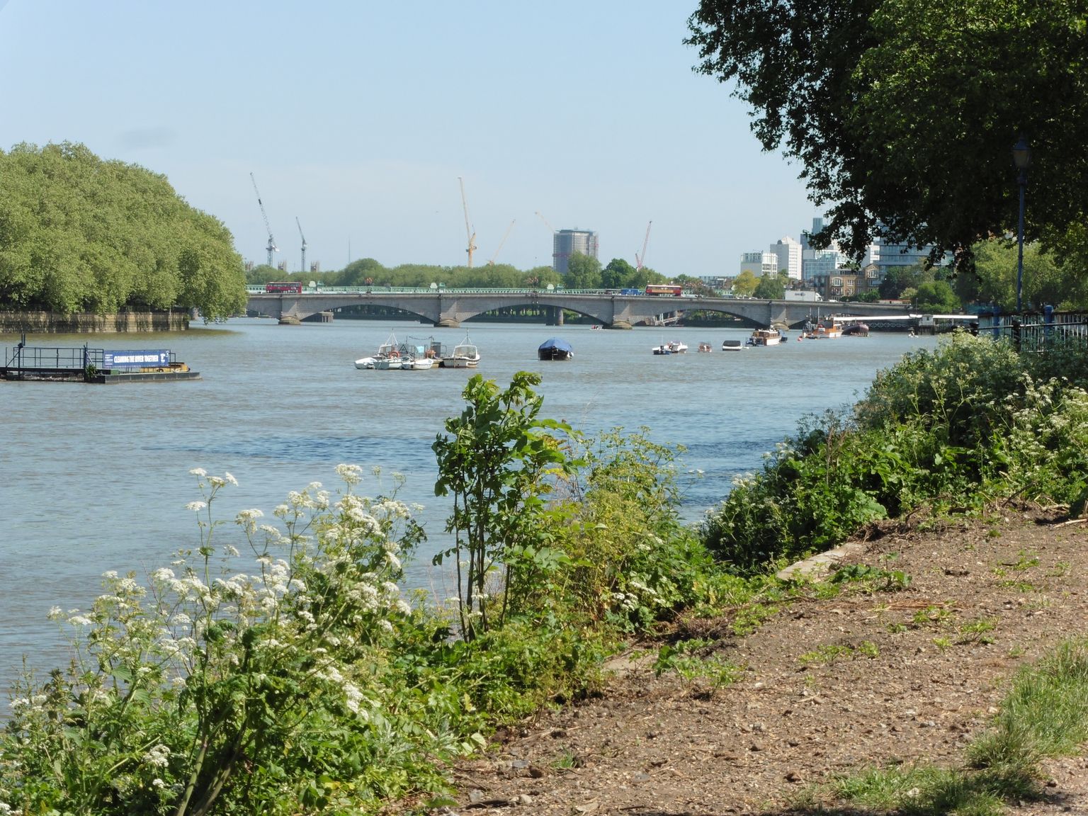
The Thames Path near Craven Cottage, looking to Putney Bridge

Area guidesFulham

Fulham

SW6 · Hammersmith and Fulham

Maintained area report

Read another area

The Thames Path near Craven Cottage, looking to Putney Bridge. Photograph by Dave Kelly.

Fulham sits in a loop of the Thames in south-west London; the guide here is drawn for the SW6 postcode district rather than the whole London Borough of Hammersmith and Fulham. It is a place of red-brick Victorian terraces, riverside parks and a genuinely village-like high street around Fulham Broadway and Parsons Green, all within easy reach of central London.

What stands out

  • A continuous riverside walk along the Thames Path through Bishop's Park and past the Fulham Pier extension towards Hammersmith, running alongside the grounds of Fulham Palace.
  • Sporting life runs deep here: Fulham FC's Craven Cottage and Chelsea FC's Stamford Bridge both trace back to the same Victorian sporting ground at Lillie Bridge, and Hurlingham Park still hosts the annual Polo in the Park tournament.
  • A high street with two centres rather than one: the pedestrianised old village heart behind Fulham Broadway, and the market and shops along North End Road.

Trade-offs

  • Fulham's popularity has driven considerable gentrification since the late twentieth century, and its Victorian housing stock and location now put it firmly among London's sought-after addresses, which is worth weighing against budget before falling for the area.
  • Redevelopment pressure has closed some long-standing local institutions in recent years, including historic pubs near the borough boundary, so what's open today is not guaranteed to stay that way.
  • Large-scale redevelopment at the eastern edge of the area, tied to the former Earl's Court exhibition site, has meant ongoing demolition and construction disruption that anyone considering that part of Fulham should check on before committing.
Postcode districtsSW6outcode-proxy-v1 · Greathome editorial boundary proxy
Local authorityHammersmith and FulhamCurrent · ONS Postcode Directory via Postcodes.io

Things to know about Fulham

  • BBC television presenter Jill Dando lived in Fulham from 1994 until her murder there in 1999.
  • Actor Daniel Radcliffe comes from Fulham.
  • Hans Zimmer, double Oscar winner, launched his career in a studio behind the Lillie Langtry public house in Lillie Road in the 1970s.
  • Fulham FC's Craven Cottage and Chelsea FC's Stamford Bridge both trace back to the same Victorian sporting ground at Lillie Bridge.
  • Fulham Palace was the country residence of the Bishops of London for centuries, and Sands End holds the reputedly oldest surviving gasholder in the World.

Life here

  • The Thames riverside walk in Bishop's Park is now continuous past the Fulham Pier extension towards Hammersmith Bridge, past the Crabtree pub and The River Cafe.
  • Hurlingham Park hosts the annual Polo in the Park tournament, and the Hurlingham Club remains the historic home of polo in the United Kingdom.
  • Fulham has five active Bowls clubs: The Bishops Park Bowls club, The Hurlingham Park Bowls Club, Normand Park Bowls Club, The Parson's Green Bowls club and The Winnington in Bishops Park.
  • The pedestrianised heart of old Walham Green, behind Fulham Broadway, is bordered by cafes, bars and a dance studio in the old Fulham Public Baths.
  • The performing arts continue in Fulham through the Fulham Symphony Orchestra and the Fulham Opera, with St John's Parish Church staging choral and instrumental concerts.
  • North End Road remains Fulham's unofficial high street and still has a street market.

History and what it is known for

  • The name Fulham comes from Old English, Fulla's hemmed-in land, and is spelt Fuleham in the 1066 Domesday Book.
  • Excavations near Fulham Palace have revealed Neolithic riverside settlement and Roman activity during the third and fourth centuries AD.
  • Fulham Palace was the country residence of the Bishops of London for a millennium, with the manor said to have been granted to Bishop Erkenwald around the year 691 or acquired by Bishop Waldhere in AD 704.
  • In 1824 the Imperial Gas Light and Coke Company, the first public utility company in the World, bought the Sandford estate in Sands End, and its number 2 gasholder, completed in 1830, is reputed to be the oldest gasholder in the World.
  • The first organised sporting activity in Fulham took place at the Lillie Bridge Grounds in the 1860s, introducing British Amateur Athletics and the first codified Boxing under Marquess of Queensberry Rules; after a riot destroyed the Grounds in 1889, Fulham F.C.'s Craven Cottage and Chelsea F.C.'s Stamford Bridge replaced them.
  • Fulham has undergone significant gentrification since the late 20th century, and by the 2000s had established itself as one of London's most desirable Zone 2 neighbourhoods.

Notable connections

  • Daniel Radcliffe — actor, comes from Fulham
  • Jill Dando — BBC television presenter, lived in Fulham from 1994 until her murder there in 1999
  • Hans Zimmer — double Oscar winner, launched his career in a studio behind the Lillie Langtry public house in Lillie Road in the 1970s
  • Linford Christie — Olympian athlete who attended Henry Compton School
  • Geoffrey de Havilland — aviation pioneer, built his first aeroplane at his workshop in Fulham in 1909
  • Janet Street-Porter — journalist who grew up in Fulham

Background from Fulham on Wikipedia (CC BY-SA 4.0) and Wikidata (CC0), summarised for this guide. Details change — check anything that matters to you.

Everyday life

Life in Fulham tends to orbit two hubs: the pedestrianised old heart of Walham Green behind Fulham Broadway, with its cafes, bars and a dance studio housed in the former public baths, and North End Road, still home to a working street market. Riverside days are easy to imagine, following the Thames Path through Bishop's Park and on past the Fulham Pier extension towards Hammersmith. Sport and community life are unusually intertwined: several bowls clubs operate across the area's parks, Hurlingham Park draws crowds for its Polo in the Park tournament, and the Fulham Symphony Orchestra and Fulham Opera keep live performance going alongside concerts at St John's Parish Church.

Housing character

The housing here reflects a long run of Victorian and Edwardian development on what was, into the twentieth century, still a largely working-class area of market gardens and industry. Genteel pockets grew up early around North End, Parsons Green, Eel Brook Common, South Park and the Hurlingham Club, and it was this Victorian terraced stock, together with the riverside setting, that drew the professionals and families who reshaped Fulham's character from the late twentieth century onwards. The result today is a mix of grander houses near the river and Hurlingham, closely-packed terraces further from the water, and flatted and newer riverside development around Chelsea Harbour and Imperial Wharf.

Getting around

Fulham is served by the District line, with stations including Putney Bridge, Parsons Green and Fulham Broadway, and by the West London Line through West Brompton and Imperial Wharf. Its position in the loop of the Thames means bridges matter for how the area connects outward, notably Putney Bridge to the south-west, with routes north towards Hammersmith and Chelsea. The Thames Path itself is a genuine local amenity for walking and cycling rather than just a scenic route, running the length of the riverside from Bishop's Park onward.

Things to investigate

Ask what has changed recently rather than relying on an older description of the area: pubs and small businesses near the borough boundary have closed under redevelopment pressure in the past decade, and the long-running redevelopment on the site of the former Earl's Court exhibition centres, on Fulham's eastern edge, continues to reshape that end of the area with ongoing demolition and construction. It is also worth checking which stretch of Fulham a listing actually sits in: the character changes noticeably between the riverside around Hurlingham and Bishop's Park, the shopping streets around Fulham Broadway and Parsons Green, and the area around North End Road and West Kensington to the north.

Schools

Measured by distance from the area centre, straight line. Primary is a walk and secondary is a journey, so they are counted on different radii. Ofsted's published judgements, not a Greathome rating.

Primarystate-funded, within 2 km

21 schools

Judged by Ofsted
21
At least Good
20
Outstanding or equivalent
3
Below Good
1

Secondarystate-funded, within 5 km

26 schools

Judged by Ofsted
26
At least Good
26
Outstanding or equivalent
10
Below Good
0

37 open schools of every phase sit within 2 km, 8 of them independent. Independent schools carry no Ofsted judgement in this release, so they appear in the total and never in the judged figures. Nothing here establishes catchment, admissions eligibility or available places.

The nearest 6 schools, with their published judgement
SchoolPhaseDistancePublished judgement
All Saints CofE Primary SchoolPrimary0.2 kmSchool remains Good · Ungraded inspection
Burlington House SchoolNot applicable0.2 kmNo published judgement
Parsons Green Prep SchoolNot applicable0.3 kmNo published judgement
Thomas's AcademyPrimary0.4 kmSchool remains Good · Ungraded inspection
St John's Walham Green Church of England Primary SchoolPrimary0.6 kmOutstanding · Overall effectiveness, pre-September 2024
Ormiston Bridge AcademyNot applicable0.7 kmGood · Overall effectiveness, pre-September 2024

Open Schools & Education

Housing market context

£725,562average house price across Hammersmith and Fulham, June 2026

A year earlier the same measure was £836,877, a change of -13.3%.

Average price across the whole local authority for one month, from the ONS series built on HM Land Registry UK House Price Index data. It is not a neighbourhood median and not a valuation of any property. Two guides in the same borough share this figure while their streets differ. House-price data is revised, and recent months are the most likely to move.

Source: Average house price by local authority, Office for National Statistics, from HM Land Registry UK House Price Index.

Boundary

Fulham, taken as the SW6 postcode district. A postcode-district proxy, not an approved polygon. These are postcode districts standing in for an approved polygon. Present every count as "in these postcode districts", never as a neighbourhood or town-centre figure.

Sources

Evidence checked 2026-09-13. Last content change 2026-09-13. Next review 2026-09-20.

What is already known about Fulham

Geography from the official record. A district or place name is a group of postcodes, not one address.

Live postcodes
1,506 in SW6
Localities
Fulham Reach, Fulham Town, Lillie, Munster
Local authority
Hammersmith and Fulham
Country
England
Centre postcode
SW6 4HL
Postcode-point mapFulham

The pin uses Postcodes.io coordinates, not an exact entrance or title boundary.

Open map

Official records around this point

Point sources need one coordinate, so these are anchored on SW6 5JJ — the live postcode nearest the centre of the area. They describe that point, not every street. Crime is counted across the whole Walham Green policing neighbourhood, which is the Police.uk boundary containing SW6 5JJ — a named area can span several of them, so this is the one covering the centre of Fulham, not all of it. Each keeps its source, its geography and its limits. Counts are counts: an incident total is not a safety measure, and an empty planning result is not a completed search.

Police.uk · Walham Green neighbourhood

Recorded incidents

Connected
127records in
August 2026
Anti-social behaviour41
Violence & sexual offences31
Shoplifting26
Public order7
Other theft6
Drugs5

One month of records for the Walham Green policing neighbourhood — the boundary police.uk itself shows, so this figure should match theirs. Not a year. Locations are anonymised to a nearby street, not an address. Counts are not adjusted for population, visitors or reporting differences and must not be treated as a neighbourhood quality score.

List the 127 records
CategoryRecorded nearLatest outcome
Anti-social behaviourOn or near Barclay RoadNo outcome published yet
Anti-social behaviourOn or near Cedarne RoadNo outcome published yet
Anti-social behaviourOn or near Epirus RoadNo outcome published yet
Anti-social behaviourOn or near Gironde RoadNo outcome published yet
Anti-social behaviourOn or near Haldane RoadNo outcome published yet
Anti-social behaviourOn or near Jerdan PlaceNo outcome published yet
Anti-social behaviourOn or near Mirabel RoadNo outcome published yet
Anti-social behaviourOn or near NightclubNo outcome published yet
Anti-social behaviourOn or near Palace MewsNo outcome published yet
Anti-social behaviourOn or near Shorrolds RoadNo outcome published yet
Anti-social behaviourOn or near SupermarketNo outcome published yet
Anti-social behaviourOn or near Vanston PlaceNo outcome published yet
Anti-social behaviourOn or near Wansdown PlaceNo outcome published yet
Bicycle theftOn or near Epirus MewsInvestigation complete; no suspect identified
Bicycle theftOn or near Fulham BroadwayInvestigation complete; no suspect identified
BurglaryOn or near Gironde RoadUnder investigation
DrugsOn or near Harbledown RoadUnder investigation
DrugsOn or near NightclubUnder investigation
DrugsOn or near NightclubAwaiting court outcome
Other theftOn or near Barclay RoadInvestigation complete; no suspect identified
Other theftOn or near Fulham BroadwayInvestigation complete; no suspect identified
Other theftOn or near Haldane RoadUnable to prosecute suspect
Other theftOn or near Shopping AreaUnder investigation
Other theftOn or near Shopping AreaInvestigation complete; no suspect identified
Possession of weaponsOn or near SupermarketOffender given a caution
Public orderOn or near Cedarne RoadUnder investigation
Public orderOn or near Epirus MewsUnder investigation
Public orderOn or near Fulham BroadwayUnable to prosecute suspect
Public orderOn or near NightclubUnder investigation
Public orderOn or near Shopping AreaUnder investigation
Public orderOn or near Vanston PlaceUnder investigation
RobberyOn or near North End RoadUnder investigation
ShopliftingOn or near Darlan RoadInvestigation complete; no suspect identified
ShopliftingOn or near Epirus MewsUnder investigation
ShopliftingOn or near Epirus MewsInvestigation complete; no suspect identified
ShopliftingOn or near Epirus MewsAwaiting court outcome
ShopliftingOn or near Epirus MewsInvestigation complete; no suspect identified
ShopliftingOn or near Fulham BroadwayInvestigation complete; no suspect identified
ShopliftingOn or near Fulham BroadwayAwaiting court outcome
ShopliftingOn or near Fulham BroadwayInvestigation complete; no suspect identified
ShopliftingOn or near Fulham BroadwayUnder investigation
ShopliftingOn or near Fulham BroadwayInvestigation complete; no suspect identified
ShopliftingOn or near Jerdan PlaceInvestigation complete; no suspect identified
ShopliftingOn or near North End RoadInvestigation complete; no suspect identified
ShopliftingOn or near Shopping AreaInvestigation complete; no suspect identified
ShopliftingOn or near Shopping AreaUnable to prosecute suspect
ShopliftingOn or near Shopping AreaInvestigation complete; no suspect identified
ShopliftingOn or near SupermarketInvestigation complete; no suspect identified
ShopliftingOn or near SupermarketUnder investigation
ShopliftingOn or near SupermarketInvestigation complete; no suspect identified
Theft from the personOn or near Jerdan PlaceUnder investigation
Theft from the personOn or near Vanston PlaceInvestigation complete; no suspect identified
Vehicle crimeOn or near Barclay RoadInvestigation complete; no suspect identified
Vehicle crimeOn or near Haldane RoadUnder investigation
Vehicle crimeOn or near Vanston PlaceAwaiting court outcome
Vehicle crimeOn or near Wheatsheaf TerraceInvestigation complete; no suspect identified
Violence & sexual offencesOn or near A304Under investigation
Violence & sexual offencesOn or near Cedarne RoadUnder investigation
Violence & sexual offencesOn or near Epirus MewsUnder investigation
Violence & sexual offencesOn or near Epirus RoadUnable to prosecute suspect
Violence & sexual offencesOn or near Erin CloseUnable to prosecute suspect
Violence & sexual offencesOn or near Fulham BroadwayUnder investigation
Violence & sexual offencesOn or near Gironde RoadUnable to prosecute suspect
Violence & sexual offencesOn or near NightclubUnder investigation
Violence & sexual offencesOn or near NightclubUnable to prosecute suspect
Violence & sexual offencesOn or near North End RoadUnder investigation
Violence & sexual offencesOn or near Pulton PlaceAwaiting court outcome
Violence & sexual offencesOn or near Shopping AreaUnder investigation
Violence & sexual offencesOn or near Shopping AreaUnable to prosecute suspect
Violence & sexual offencesOn or near Shopping AreaUnder investigation
Violence & sexual offencesOn or near Wansdown PlaceUnder investigation
Violence & sexual offencesOn or near Wansdown PlaceUnable to prosecute suspect
Walham Green on the force site ↗

Planning Data · England

Intersecting designations

Connected
Conservation area

Fulham Park Gardens16

Screened at the postcode point, not a title boundary. Coverage varies by dataset and local planning authority; absence is not a clear result.

About Planning Data ↗

Planning London Datahub · 400 m

Nearby planning applications

Live feed
892applications on record
within 400 m
  1. 27 October 2026Application Received

    P7 17 Oxberry Avenue - Cert1.

    Oxberry Avenue · SW6 5SP · P/2026/02749/CLE · Hammersmith And FulhamOpen on the council's portal ↗
  2. 20 October 2026Application Received

    Q97293 - 134 New Kings Road

    Northumberland House New King's Road · SW6 4LZ · P/2026/02683/TPO · Hammersmith And FulhamOpen on the council's portal ↗
  3. 2 October 2026Application Received

    Replacement of existing external single glazed windows with double glazed windows (timber framed to front elevation, PVCu to side and rear elevations). Addition of 2 new windows to side elevations.

    Fulham Road · SW6 5SB · P/2026/02567/FR3 · Hammersmith And FulhamOpen on the council's portal ↗
  4. 24 September 2026Application Received

    Installation of new doors to replace the existing doors at ground floor level to the rear elevation; alterations to the roof of ground floor rear back addition to include the replacement of 1no rooflight with an enlarged sky lantern; lowering the floor level of the ground floor rear back addition by 600mm.

    Flat Ground Floor Hestercombe Avenue · SW6 5LJ · P/2026/02453/FUL · Hammersmith & FulhamOpen on the council's portal ↗
  5. 23 September 2026Application Received

    Replacement of existing single glazed timber framed sash and casement windows to front elevation with double glazed timber framed sash and casement windows. Replacement of existing single glazed timber framed sash windows to rear and side elevations with double glazed timber framed sash windows. Replacement of existing single glazed timber framed doors with a double glazed timber framed doors.

    Cavendish House New King's Road · SW6 4RN · P/2026/02278/FUL · Hammersmith And FulhamOpen on the council's portal ↗
  6. 23 September 2026Application Received

    895-921, Fulham Road, SW6 5HU

    915-921 915 Fulham Road · SW6 5HU · P/2026/02449/TREE · Hammersmith And FulhamOpen on the council's portal ↗

Applications near the postcode point, newest first — not applications on this property, and not a planning search. Each record originates with the London borough that validated it; the Datahub is the Greater London Authority's collection of those borough feeds, and the borough's own planning register remains the definitive record. Decisions and conditions can change after this snapshot.

About the Planning London Datahub ↗

London Crime Map

Daily essentials

Supermarkets, pharmacies, healthcare, gyms and libraries mapped near SW6 5JJ, ordered by straight-line distance. OpenStreetMap is contributed data: a place missing here is not proof it does not exist, and nothing here confirms opening hours or that a business is still trading.

24everyday places mapped within 1.2 km of the postcode point

Food shopping

8

Supermarkets and convenience stores.

  1. 78 mPlanet Plenty25-29, Fulham High StreetMap ↗
  2. 525 mCo-op Food100, New King's RoadMap ↗
  3. 808 mBudgensParsons Green Lane, Parson's GreenMap ↗
  4. 857 mLidl60, Putney High StreetMap ↗
  5. 869 mMarks & Spencer59, Putney High StreetMap ↗
  6. 906 mPutney Convenience Store69, Putney High StreetMap ↗
  7. 911 mWaitrosePutney High Street, PutneyMap ↗
  8. 1.1 kmEnca Food2, Salisbury PavementMap ↗

Health

8

Pharmacies, GP surgeries and dentists.

  1. 76 mProgressive DentistryFulham High Street, HurlinghamMap ↗
  2. 285 mBishops Park Dental Care413, Fulham Palace RoadMap ↗
  3. 485 mDamira315,317Map ↗
  4. 491 mChelsea & Fulham Dentist841, Fulham RoadMap ↗
  5. 602 mFulham Palace Pharmacy331, Fulham Palace RoadMap ↗
  6. 623 mPerfect Smile74, New King's RoadMap ↗
  7. 624 mBespoke Dental Fulham275, New King's RoadMap ↗
  8. 729 mAttelia775, Fulham RoadMap ↗

Exercise

0

Gyms, leisure centres and swimming pools.

Nothing of this kind returned within the radius.

Civic and everyday

8

Libraries, post offices and community buildings.

  1. 452 mFulham Post Office851, Fulham RoadMap ↗
  2. 823 mWandsworth Chelsea & Fulham Sea CadetsEmbankment, PutneyMap ↗
  3. 855 mFulham Library598, Fulham RoadMap ↗
  4. 997 mSands End Arts & Community CentrePeterborough Road, Parson's GreenMap ↗
  5. 1.0 kmKenyon Street Post Office58, Kenyon StreetMap ↗
  6. 1.0 kmTudor Rose Community CentreFulham Court, FulhamMap ↗
  7. 1.1 kmDawes Road Post Office105-107, Dawes RoadMap ↗
  8. 1.1 kmPutney Library5,7Map ↗

Places mapped in OpenStreetMap within this distance of the postcode point, measured straight-line, and kept only where the map tags them as the kind of place the heading claims. OpenStreetMap is volunteer-maintained and this search returns the closest matches rather than every one: a short list is not proof that nothing else is there. Distances are not walking routes, and nothing here checks opening hours, whether a surgery is accepting patients, or whether a place is still trading.

Parks and green space

Parks, playgrounds, nature and outdoor sport mapped within 1.5 km of SW6 5JJ, ordered by straight-line distance. Distance is not a walking route, and OpenStreetMap says nothing about whether a space is open to the public, its hours or its condition.

19open spaces mapped within 1.5 km of the postcode point

Parks and commons

8

Named parks, commons and village greens open to the public.

  1. 492 mBishop's ParkFulham, London Borough of Hammersmith and FulhamMap ↗
  2. 657 mHurlingham ParkFulham, London Borough of Hammersmith and FulhamMap ↗
  3. 791 mParsons GreenFulham, London Borough of Hammersmith and FulhamMap ↗
  4. 800 mLeader's GardensPutney, London Borough of WandsworthMap ↗
  5. 926 mStevenage ParkFulham, London Borough of Hammersmith and FulhamMap ↗
  6. 1.1 kmWandsworth ParkWandsworth, London Borough of WandsworthMap ↗
  7. 1.2 kmCommunal Garden SquarePutney, London Borough of WandsworthMap ↗
  8. 1.2 kmSouth ParkFulham, London Borough of Hammersmith and FulhamMap ↗

Playgrounds

5

Children’s play areas mapped as such.

  1. 488 mToddlers' PlaygroundEvent Circle, FulhamMap ↗
  2. 561 mPoint pocket Park play areaPutney Embankment Foreshore, PutneyMap ↗
  3. 1.0 kmLancaster Court PlaygroundRavensworth Court, Lancaster CourtMap ↗
  4. 1.2 kmPulton Place Play AreaPulton Place, Walham GreenMap ↗
  5. 1.3 kmLillie Road Play AreaLillie Road, HammersmithMap ↗

Nature and water

0

Nature reserves, woodland and waterside.

Nothing of this kind returned within the radius.

Outdoor sport

6

Recreation grounds, pitches and courts.

  1. 484 mFulham SkateparkEvent Circle, FulhamMap ↗
  2. 684 mFielders MeadowFulham, London Borough of Hammersmith and FulhamMap ↗
  3. 1.3 kmLillie Road Recreation GroundHammersmith, London Borough of Hammersmith and FulhamMap ↗
  4. 1.4 kmMulti Use Games AreaWest Kensington, London Borough of Hammersmith and FulhamMap ↗
  5. 1.5 km10Howard's Lane, PutneyMap ↗
  6. 1.5 km8Howard's Lane, PutneyMap ↗

Places mapped in OpenStreetMap within this distance of the postcode point, measured straight-line, and kept only where the map tags them as the kind of place the heading claims. OpenStreetMap is volunteer-maintained and this search returns the closest matches rather than every one: a short list is not proof that nothing else is there. Distances are not walking routes, and nothing here checks opening hours, whether a surgery is accepting patients, or whether a place is still trading.

Nearby pubs

Pubs mapped in OpenStreetMap within 2.0 miles of SW6 5JJ, nearest first.

Loading nearby pubs…

Look this place up in detail

Each of these opens on SW6 5JJ, the postcode anchoring Fulham, and queries its own source only when you open it.

What this report does not cover

  • neighbourhood median sale price (not_available): Only a local-authority average is connected, from ONS. A neighbourhood median needs enough geocoded transactions inside the guide boundary, which the per-postcode HMLR queries cannot supply.
  • rents (not_available): No rent series is connected. Advertised rents and official all-tenancy measures are different things and neither is available here yet.
  • journey times (not_available): No journey planner is connected. Transport is measured as nearby stops, not as time to anywhere. TfL PTAL and journey-time APIs would replace it for London.
  • school admissions history (not_available): Admission arrangements are held by each admission authority and are not in the GIAS or Ofsted snapshots.
  • licensed premises and venues (not_available): No licensing register or venue dataset is connected. Food-hygiene categories are not a pub register.
  • image rights (not_yet_verified): No licensed image library is connected. Return an image brief rather than an asset.
  • approved boundary polygon (not_yet_verified): Boundaries are postcode-district proxies. Counts describe the districts named, not a town-centre polygon.