
Area guidesSutton
Sutton
SM1 · Sutton, London
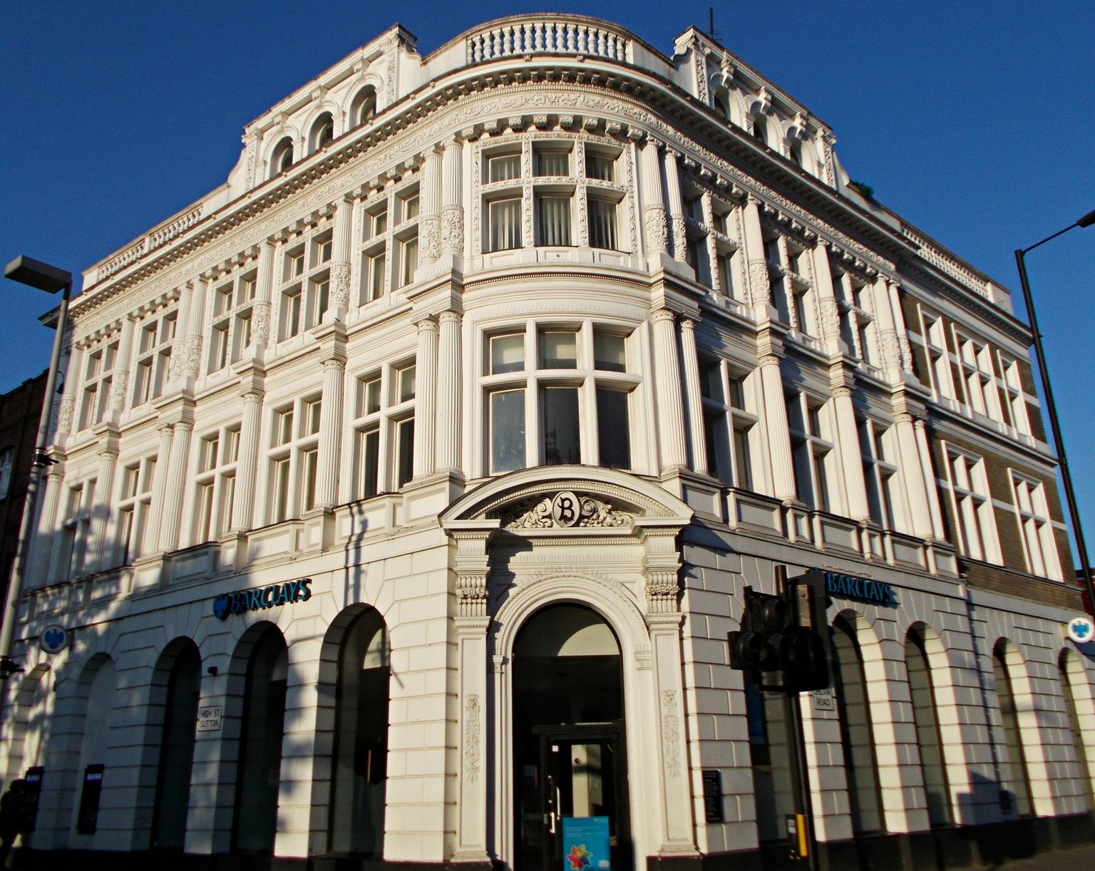
Barclays Bank building on the High Street corner, Sutton. Photograph by A P Monblat.
Sutton is a railway town turned London suburb, built almost entirely by the Victorians once the line to the city arrived in 1847 and the population raced ahead. The town centre — what this guide treats as the SM1 postcode district, not the wider London Borough of Sutton — is a pedestrianised high street of polychrome Victorian and Edwardian fronts, a scattering of public art, and a genuine claim to be a hub for film and TV work in south-west London alongside nearby Wimbledon Studios. It reads as a solidly suburban, self-sufficient sort of place: a proper high street rather than a village green, with the Royal Marsden and Institute of Cancer Research anchoring a serious life-sciences campus at its southern edge.
What stands out
- A long-running, low-key filming location: the high street has stood in for scenes in The Return of Mr Bean, The Bill and the E4 sitcom Phoneshop, and for a 2013 sequence in the Hollywood thriller Black Sea shot outside Sutton Grammar School.
- A genuinely deep music footnote: the Red Lion pub on the high street (now the Winning Post) is where Charlie Watts and Bill Wyman became permanent members of the Rolling Stones in January 1963.
- One of the world's oldest working shops of its kind — Pearson Cycles, trading from the same high street site since the 1890s and recognised by Guinness World Records as the oldest bicycle shop in the world.
Trade-offs
- The retail centre is substantial (rated one of London's more important shopping destinations) but much of the wider town's charm is administrative and civic rather than picturesque — this is a working suburban centre, not a chocolate-box market town.
- Sutton town centre (SM1) is a postcode-district proxy, not an approved neighbourhood boundary, and it sits inside a much larger London Borough of Sutton — anything said about 'the area' here should not be assumed to hold for Cheam, Carshalton or Wallington.
- Two of the town's cultural venues have had rocky recent histories: the Secombe Theatre closed permanently in 2016 after its operating trust went into administration, and the newer Sound Lounge music venue suffered a vandalism attack in September 2025, even as its fundraising response showed strong local support.
Things to know about Sutton
- Jack Draper, the professional tennis player, was born in Sutton.
- Charlie Watts and Bill Wyman became permanent members of the Rolling Stones at a gig in the Red Lion pub (now the Winning Post) on Sutton High Street on 23 January 1963.
- The high street has featured on screen repeatedly: The Return of Mr Bean, episodes of The Bill, the E4 sitcom Phoneshop, and a 2013 scene from the Hollywood film Black Sea shot outside Sutton Grammar School with Jude Law.
- Pearson Cycles, trading from the same Sutton High Street site since the 1890s, is recognised by Guinness World Records as the oldest bicycle shop in the world.
Life here
- Sutton High Street runs for nearly a mile from Sutton Green to the station and is one of London's more significant retail centres, with a pedestrianised central stretch, pavement seating and an expanding range of restaurants covering cuisines from French and Lebanese to Malaysian, Thai and Sri Lankan.
- A monthly pop-up market supports local makers, and summer brings an outdoor 'Sunset Cinema' in deckchairs plus arts and crafts fairs and occasional French, Italian and Continental markets.
- The Imagine festival of arts, launched in 2006, now receives Arts Council England funding.
- The Sound Lounge, a grassroots concert venue on the high street, hosts blues, Americana, folk and roots music and became the country's first grassroots music venue certified carbon neutral in July 2021; it suffered a vandalism attack in September 2025 that drew a large community fundraising response.
- A permanent rainbow pedestrian crossing (installed mid-2020) and the country's first permanent transgender pedestrian crossing (May 2021) sit near the civic centre as visible markers of local LGBT+ inclusion efforts.
- The Royal Marsden Hospital and the Institute of Cancer Research anchor a growing life-sciences campus at the southern end of town, including the Oaks Cancer Centre, opened by Prince William in June 2023.
History and what it is known for
- The name Sutton is recorded as 'Sudtone' in the 1086 Domesday Book, from Old English words meaning 'south farm'; by then it had about 30 houses and 200 people.
- The manor passed through Chertsey Abbey, was sold to Henry VIII in 1538 and granted to Sir Nicholas Carew, then passed between the Crown and various owners over the following centuries.
- Sutton railway station opened in 1847, and the town's population more than doubled in the following decade as it grew from village to town.
- Sutton Grammar School (now Sutton Grammar School for Boys) opened in 1899, and Sutton High School for Girls was founded in 1884.
- 434 bombs were dropped on Sutton and Cheam during the Second World War, with the Commonwealth War Graves Commission listing 187 civilian casualties.
- In 1959, local resident George Edgar Alcock's campaign to preserve an avenue of copper beech trees led to the founding of the Sutton and Cheam Society, a local amenity group.
Notable connections
- Jack Draper — Professional tennis player, born in Sutton.
- Penelope Keith — Actress known for The Good Life, born in Sutton.
- Katie Melua — Singer-songwriter, lived in Gander Green Lane, Sutton.
- Quentin Crisp — Writer and raconteur, born in Sutton.
- Harry Secombe — Comedian and entertainer, was a longstanding local resident; Sutton's Secombe Theatre was named after him.
- Noël Coward — Actor and playwright, lived on Lenham Road, Sutton, between the ages of seven and ten.
On screen
- The Return of Mr Bean — Filmed on Sutton High Street.
- The Bill — Several episodes filmed in Sutton.
- Phoneshop — The E4 sitcom was filmed in a vacant shop unit on Sutton High Street.
- Black Sea — A 2013 scene in the Hollywood thriller, featuring Jude Law, was shot outside Sutton Grammar School.
Background from Sutton, London on Wikipedia (CC BY-SA 4.0) and Wikidata (CC0), summarised for this guide. Details change — check anything that matters to you.
Everyday life
The high street is the spine of daily life: nearly a mile of shops running from Sutton Green down to the station, pedestrianised in its central stretch with room for pavement seating outside the growing range of restaurants and cafés. A monthly pop-up market supports local makers and entrepreneurs, and in summer the street hosts an outdoor 'Sunset Cinema' in deckchairs, plus arts and crafts fairs and occasional French, Italian and Continental markets. The annual Imagine festival of arts, running since 2006 with Arts Council England support, is one of the fixed points in the local cultural calendar, alongside exhibitions at Sutton Central Library's Art Gallery Space and gigs at the grassroots, carbon-neutral Sound Lounge venue.
Public art gives the centre some personality beyond the shopfronts: a large heritage mosaic near the town square depicts local history including Henry VIII's Nonsuch Palace, a twin-towns mural marks Sutton's links with European sister towns, and a permanent rainbow crossing and the country's first permanent transgender pedestrian crossing sit near the civic centre as visible markers of the town's LGBT+ inclusion efforts.
Housing character
The building stock is overwhelmingly a product of the railway boom: Victorian terraces and villas dominate the centre and the 'Newtown' residential quarter just east of the high street, with Edwardian housing well represented too, especially the grand villas of the Landseer Road conservation area. There's a pocket of Arts and Crafts character in the Sutton Garden Suburb conservation area, some 1930s art deco and moderne touches, and a handful of tall, recent apartment developments — the eighteen-storey Aspects tower among them — that stand out against the low-rise Victorian grain. A rare survivor from well before the railway era is the mid-18th-century Sutton Lodge on Brighton Road, reputedly once a hideaway for the future George IV.
Four conservation areas protect the most distinctive housing pockets, and the town centre itself was designated a Historic England Heritage Action Zone in 2017, which has put heritage front and centre in how new development is judged. Large-scale regeneration has been reshaping the centre for a decade, from the Old Gas Works redevelopment at the High Street's northern end to ongoing council plans for the Civic Centre site and the St Nicholas Centre, so expect a town centre in active transition around otherwise settled residential streets.
Getting around
Sutton railway station, opened in 1847, is what built the town and remains its centre of gravity, with the Sutton Link tram extension to the station introduced in 2020 as a more recent addition to the network. The high street and civic core are walkable and pedestrianised, which suits a car-free Saturday of shopping and browsing better than a cross-town errand run.
This guide holds no journey-time or transport-frequency data for Sutton, so anyone weighing a daily commute should check live services directly with the relevant operators rather than relying on general impressions of 'well-connected suburbs'.
Things to investigate
Sutton town centre sits within the London Borough of Sutton but is not the same thing as it: figures, planning decisions and school catchments quoted for 'the borough' may not describe this specific postcode district, so check which geography any claim you read is actually using.
Several major regeneration projects — the Civic Centre site, Russettings, the former Secombe Theatre, and the planned Throwley Yard cultural hub — are at various stages of council disposal or redevelopment, so the shape of the town centre a few years from now may differ noticeably from how it looks today. Worth checking current planning status before assuming any particular vision has been built.
This guide has no connected data on neighbourhood house prices, rents, journey times, school admissions history or a venue/licensing register for Sutton — treat any such figures found elsewhere as unverified until checked against an official source.
Schools
No school evidence was returned for this area centre.
Boundary
Sutton town centre and its surrounds, taken as the SM1 postcode district. SM1 is a district proxy, not the London Borough of Sutton; borough-level figures are labelled as such. These are postcode districts standing in for an approved polygon. Present every count as "in these postcode districts", never as a neighbourhood or town-centre figure.
Sources
- Average house price by local authority — Office for National Statistics, from HM Land Registry UK House Price Index
- Get Information About Schools — Department for Education
- Ofsted inspection management information — Ofsted
- Street-level crime data — Police.uk
- Postcode and administrative geography — Postcodes.io / ONS
Evidence checked 2026-09-13. Last content change 2026-09-13. Next review 2026-09-20.
Geography and local records
Local records load separately while you read the guide.
What this report does not cover
- neighbourhood median sale price (not_available): Only a local-authority average is connected, from ONS. A neighbourhood median needs enough geocoded transactions inside the guide boundary, which the per-postcode HMLR queries cannot supply.
- rents (not_available): No rent series is connected. Advertised rents and official all-tenancy measures are different things and neither is available here yet.
- journey times (not_available): No journey planner is connected. Transport is measured as nearby stops, not as time to anywhere. TfL PTAL and journey-time APIs would replace it for London.
- school admissions history (not_available): Admission arrangements are held by each admission authority and are not in the GIAS or Ofsted snapshots.
- licensed premises and venues (not_available): No licensing register or venue dataset is connected. Food-hygiene categories are not a pub register.
- image rights (not_yet_verified): No licensed image library is connected. Return an image brief rather than an asset.
- approved boundary polygon (not_yet_verified): Boundaries are postcode-district proxies. Counts describe the districts named, not a town-centre polygon.