
Area guidesWembley
Wembley
HA9 · Brent, London
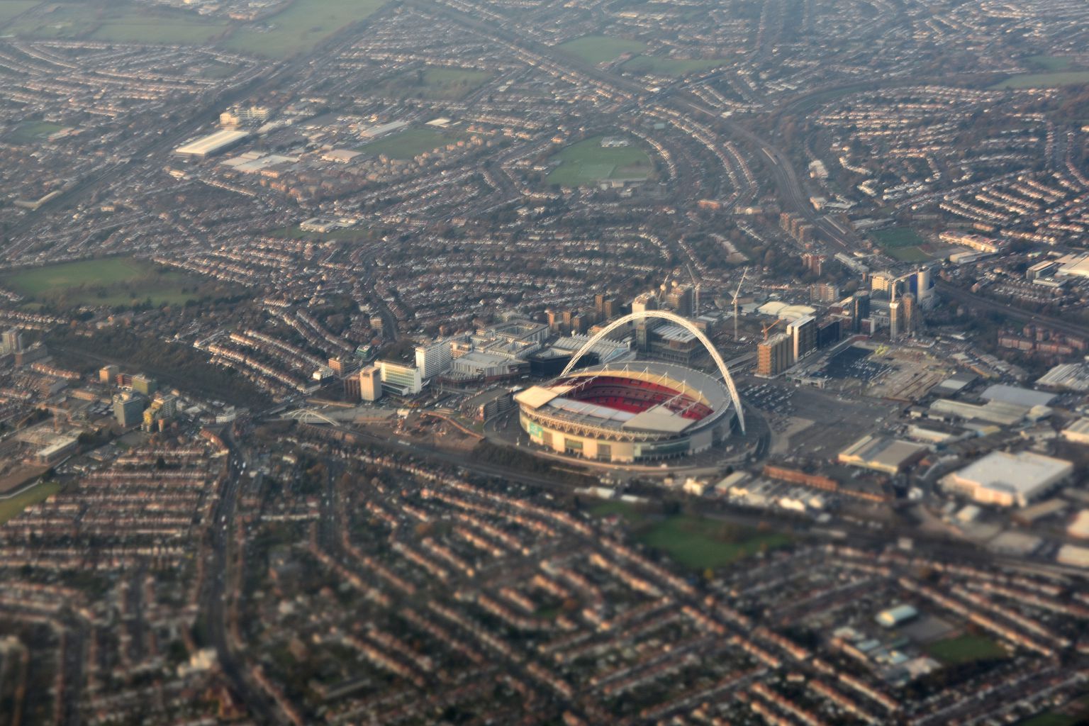
Wembley Stadium and the streets around it from the air. Photograph by Cmglee.
Wembley here means the HA9 postcode district: Wembley Park, the stadium and arena complex, and the older town centre around the High Road, rather than Wembley Central, which sits mostly in the neighbouring HA0 district and isn't counted in this guide. It's a place that lives a double life — a long-standing, ordinary High Road community built around Victorian and interwar streets, sitting next to one of the most recognisable event venues in world sport and music. On a non-event day it can feel quiet and residential; on a big match or concert night, tens of thousands of people pass through in a few hours.
What stands out
- Wembley Stadium and the Grade II-listed SSE Arena (the former Empire Pool, built for the 1934 Empire Games) put Wembley Park among London's biggest event destinations, generating a very different rhythm from the surrounding streets.
- Ealing Road has built a reputation as a South Asian jewellery and gold quarter, drawing shoppers from well beyond north-west London, alongside the Shree Sanatan Hindu Mandir and Central Mosque nearby.
- The area has produced or hosted a striking run of well-known names in music, sport and comedy — from Rolling Stones drummer Charlie Watts and The Who's Keith Moon to actor Riz Ahmed — which locals tend to mention with quiet pride rather than fanfare.
Trade-offs
- Event days at the stadium and arena bring large, temporary crowds, road closures and a different pace to normal life — worth weighing if you value predictability on your doorstep.
- The traditional High Road shopping stretch has been through a long decline since its mid-century peak, and retail energy has shifted towards the newer London Designer Outlet at Wembley Park, leaving the two parts of the area feeling quite different in character.
- Because HA9 excludes Wembley Central, anyone weighing up 'Wembley' as a whole needs to look at that neighbouring district separately rather than assume this guide covers it.
Things to know about Wembley
- Actor Riz Ahmed, born in Wembley and star of Chris Morris's Four Lions, partly set his TV comedy Bait in the area.
- Two of British rock's most famous drummers were born here: Charlie Watts of the Rolling Stones and Keith Moon of The Who.
- Ealing Road has built a reputation as a South Asian jewellery and gold quarter, drawing shoppers from as far as Leicester.
- The original Wembley Stadium hosted the FA Cup Final from 1923 and the 1924–25 British Empire Exhibition shaped much of what is now Wembley Park.
Life here
- Ealing Road is known for its concentration of South Asian jewellery and gold shops, alongside the Shree Sanatan Hindu Mandir and the Central Mosque (a converted former Presbyterian church).
- The London Designer Outlet and its pedestrianised street at Wembley Park have become the area's main modern shopping draw, alongside the older High Road shopping stretch.
- The Ace Cafe, a transport café dating to 1938, hosts car and bike meets for enthusiasts from around the world.
- Fryent Country Park, King Edward VII Park and the Grand Union Canal towpath provide green space and walking routes.
- Wembley F.C. and South Kilburn F.C., two local non-League football clubs, play at Vale Farm Stadium in nearby Sudbury.
History and what it is known for
- The name Wembley derives from the Old English 'Wemba's lea' (Wemba's meadow or clearing), first recorded in a charter of 825.
- The manor of Wembley passed through the Page family, who commissioned landscape gardener Humphry Repton to design what became Wembley Park.
- Wembley Park hosted the British Empire Exhibition of 1924–25; remnants of its buildings survived until redevelopment in the 2000s.
- The original Wembley Stadium opened for the 1923 FA Cup Final and remained in use for 77 years before closing in 2000; the rebuilt stadium opened in 2007.
- The SSE Arena (now known by that name) opened in 1934 as the Empire Pool for the 2nd Empire Games and is Grade II listed.
- Wembley's High Road shopping area declined from its 1970s peak (11th-best shopping destination in London in 1971) to 24th by 1987, prompting major regeneration from the mid-2000s led by St Modwen and Quintain.
Notable connections
- Charlie Watts — Rolling Stones drummer, born in Wembley.
- Keith Moon — The Who's drummer, born in Wembley.
- Riz Ahmed — Actor born in Wembley, star of Four Lions; his TV comedy Bait was partly set there.
- Arthur Lucan — Comedian known for 'Old Mother Riley', lived in Wembley; commemorated with the area's only English Heritage blue plaque, on Forty Lane.
- John D Barrow — Cosmologist and Templeton Prize winner, born in Wembley in 1952 and educated at Barham Primary School.
- Luciana Berger — Politician who grew up in Wembley.
On screen
- Bait — TV comedy created by and starring Riz Ahmed, partly set in Wembley, where Ahmed was born.
Background from Wembley on Wikipedia (CC BY-SA 4.0) and Wikidata (CC0), summarised for this guide. Details change — check anything that matters to you.
Everyday life
Day to day, Wembley Park's identity has been reshaped by two decades of regeneration around the stadium: the London Designer Outlet and its pedestrianised street sit alongside newer apartment blocks, cafés and a public square that didn't exist before the 2000s rebuild. Around the older town centre, Ealing Road remains a genuine draw in its own right, known for its concentration of South Asian jewellery and gold shops, and for the Shree Sanatan Hindu Mandir and Central Mosque (the latter a converted former Presbyterian church) that anchor community life nearby.
For green space and quieter pursuits, King Edward VII Park and the Grand Union Canal towpath near Sudbury Golf Course offer places to walk, while Fryent Country Park — on the site of one of Wembley's former golf clubs — gives more open, semi-rural ground to the north. Motoring enthusiasts know the Ace Cafe, a transport café dating to 1938 that still hosts car and bike meets drawing visitors nationally and internationally. Two local non-League football clubs, Wembley F.C. and South Kilburn F.C., play at Vale Farm Stadium just over the boundary in Sudbury, which is also home to a sports centre used by residents.
Housing character
Away from the stadium's newer apartment developments, most of Wembley's housing dates from the interwar expansion of the area, when the population grew rapidly as railways and the tube extended out from central London: expect semi-detached houses and terraces from that period, with a smaller number of detached houses. Around Wembley Park itself, recent regeneration has added modern apartment blocks, including tall residential towers replacing former council office buildings such as Chesterfield House. This gives the area a visible contrast between older suburban streets and newer high-rise development clustered close to the stadium and arena.
Getting around
Wembley is served by more than one rail identity, reflecting its layered history: Wembley Park station carries the Metropolitan and Jubilee lines, while Wembley Stadium station (on what is now the Chiltern Main Line) exists largely to serve event traffic and has been renamed several times as the venue's importance grew. Wembley Central, just outside this guide's boundary, adds London Overground and West Coast Main Line services. Bus route 18 runs through the area along a corridor once served by tram and trolleybus routes, and is among the busier bus routes in London. On stadium or arena event days, expect significantly higher pedestrian and public transport volumes, particularly around Wembley Way, the walkway linking Wembley Park station to the stadium.
Things to investigate
Treat 'Wembley' carefully when researching further: this guide covers only the HA9 postcode district, which takes in Wembley Park and the stadium, not Wembley Central, which lies mostly in HA0 — check which one any figures or listings actually refer to. We hold no local rent series, no neighbourhood-level sale price median (only a wider local-authority average is connected), no journey-time data, and no licensing register for pubs and venues here, so treat any such claims from other sources with caution. School admission arrangements sit with individual admission authorities and aren't covered by the establishment counts we hold, so check directly with schools of interest. It's also worth asking current residents or the council about event-day traffic management and noise, and about the pace and phasing of ongoing development around Wembley Park, since regeneration here has continued in stages over nearly two decades.
Schools
No school evidence was returned for this area centre.
Boundary
Wembley, taken as the HA9 postcode district. HA9 covers Wembley Park and the stadium; Wembley Central lies largely in HA0 and is not counted here. These are postcode districts standing in for an approved polygon. Present every count as "in these postcode districts", never as a neighbourhood or town-centre figure.
Sources
- Average house price by local authority — Office for National Statistics, from HM Land Registry UK House Price Index
- Get Information About Schools — Department for Education
- Ofsted inspection management information — Ofsted
- Street-level crime data — Police.uk
- Postcode and administrative geography — Postcodes.io / ONS
Evidence checked 2026-09-13. Last content change 2026-09-13. Next review 2026-09-20.
Geography and local records
Local records load separately while you read the guide.
What this report does not cover
- neighbourhood median sale price (not_available): Only a local-authority average is connected, from ONS. A neighbourhood median needs enough geocoded transactions inside the guide boundary, which the per-postcode HMLR queries cannot supply.
- rents (not_available): No rent series is connected. Advertised rents and official all-tenancy measures are different things and neither is available here yet.
- journey times (not_available): No journey planner is connected. Transport is measured as nearby stops, not as time to anywhere. TfL PTAL and journey-time APIs would replace it for London.
- school admissions history (not_available): Admission arrangements are held by each admission authority and are not in the GIAS or Ofsted snapshots.
- licensed premises and venues (not_available): No licensing register or venue dataset is connected. Food-hygiene categories are not a pub register.
- image rights (not_yet_verified): No licensed image library is connected. Return an image brief rather than an asset.
- approved boundary polygon (not_yet_verified): Boundaries are postcode-district proxies. Counts describe the districts named, not a town-centre polygon.