
Area guidesBarnet
Barnet
EN5 · Barnet
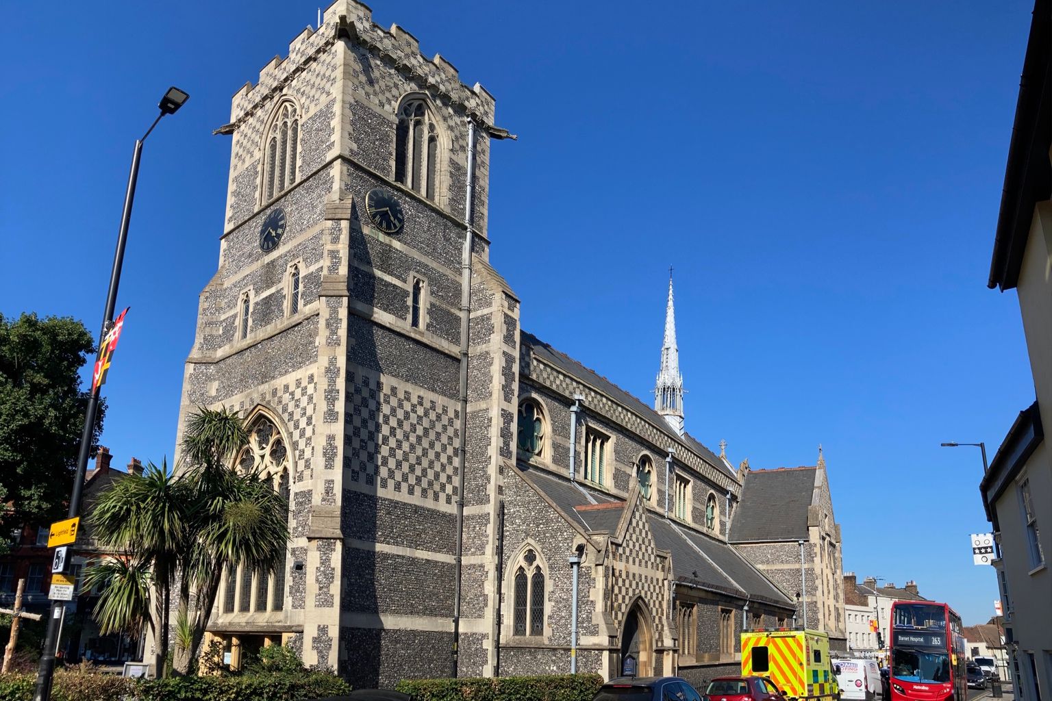
St John the Baptist church on Chipping Barnet High Street, its flint-chequer tower and spire. Photograph by Matt Brown.
Barnet - properly Chipping Barnet, or High Barnet to Tube users - sits at the northern tip of London, on the ridge where the old Great North Road climbs out of the city towards Hertfordshire. This guide covers the EN5 postcode district, a proxy for the town centre and its immediate streets rather than the much larger London Borough of Barnet that shares its name; the borough runs south for miles through Finchley, Whetstone and New Barnet, and coverage of 'Barnet' elsewhere often means that wider area, not this one. What EN5 offers is something rarer inside the M25: a genuine market-town high street, working shops rather than a shopping parade built to replace them, and a green edge that turns into Hertfordshire within a short walk.
What stands out
- A market town that predates London's expansion into it: Barnet's street market and historic charter fair go back centuries, and the High Street still runs the show rather than a shopping centre doing it for them.
- The Battle of Barnet, one of the decisive clashes of the Wars of the Roses, was fought on the fields north of the town in 1471 - Hadley Green and the surrounding open land still carry that history rather than having been built over.
- High Barnet station is where the Northern line runs out of road: London's Underground map ends here, and the town beyond the ticket barriers feels more like the Home Counties than inner London.
Trade-offs
- Being the literal end of the line cuts both ways: a good chance of a seat heading south, but a long ride to central London from EN5 whichever route you take, and no second Tube line nearby as a backup.
- The High Street's market-town character sits alongside a small shopping centre and a fair amount of through traffic on the old Great North Road; it doesn't have the polish of a redeveloped town centre, and some units turn over.
- Housing here leans toward family houses rather than flats, which suits people settling down but narrows the choice for anyone wanting a one-bedroom flat or new-build.
Things to know about Barnet
- In 2025/26, Barnet FC won the Vanarama National League to return to the EFL League Two, having been relegated from League Two at the end of the 2017/18 season.
- Elaine Paige, Mark Kermode, Stephanie Beacham, Nadine Coyle and Mike Skinner were all born or grew up in the town, a striking cluster of music, stage and film names for a small London district.
- Barnet Fair, a horse fair chartered by Queen Elizabeth I and dating back to 1588, still takes place each September, and gave English its rhyming slang for hair, barnet.
- High Barnet's high street has an Everyman cinema, the Barnet Museum and the All Saints Art Centre, alongside local festivals such as the High Barnet Chamber Music Festival and the Barnet Medieval Festival.
Life here
- High Barnet's high street is anchored by an Everyman cinema, the Barnet Museum and the All Saints Art Centre, plus a run of restaurants and pubs.
- Nearby green space includes Ravenscroft local park, Barnet recreational park, Old Court House Recreation Ground, and King George's Field, a memorial to King George V.
- Sport runs deep here: Barnet FC play in the EFL League Two after winning the Vanarama National League in 2025/26 and moved from Underhill Stadium to The Hive Stadium in Stanmore; there is also London Lions F.C., Barnet Cricket Club, Shaftesbury Barnet Harriers athletics club and Barnet Elizabethans RFC.
- Local festivals include Barnet Fair each September, the High Barnet Chamber Music Festival, and the Barnet Medieval Festival.
- Amateur clubs such as East Barnet Old Grammarians and Ravenscroft Old Boys keep grassroots football going alongside the professional side.
History and what it is known for
- The Battle of Barnet in 1471 was fought nearby at Monken Hadley: Yorkist troops led by King Edward IV killed Richard Neville, Earl of Warwick, the Kingmaker, and his brother John Neville, Marquess of Montagu, in one of the most important battles of the Wars of the Roses.
- Barnet Fair, a horse fair dating to 1588, was chartered twice yearly by Queen Elizabeth I to the Lord of the Manor of Barnet, and gave its name to the rhyming slang barnet for hair.
- Barnet Market was chartered by King John on 23 August 1199 to the Abbot of St Albans, John de Cella, and is described in the source material as nearly 825 years old as of 2024.
- The name Barnet is recorded as Barneto around 1070, Barnet in 1197 and La Barnette in 1248, Old English for land cleared by burning.
- A now-disused well in High Barnet was once frequented, among others, by Samuel Pepys.
- St John the Baptist Church, built around 1400 by John de la Moote, abbot of St Albans, remains a landmark in what was the centre of the town.
Notable connections
- Elaine Paige — Theatre actress, singer and radio host, born in Barnet in 1948.
- Mark Kermode — Film critic and musician, born in Barnet in 1963.
- Stephanie Beacham — Actress, businesswoman and former model, born in Barnet in 1947.
- Mike Skinner — Rapper, singer-songwriter and record producer, born in Barnet in 1979.
- Nadine Coyle — Singer who grew up in Barnet, born in 1985.
- Martin Furnival Jones — Former Director General of MI5, born in Barnet in 1912; he died in 1997.
Background from Chipping Barnet on Wikipedia (CC BY-SA 4.0) and Wikidata (CC0), summarised for this guide. Details change — check anything that matters to you.
Everyday life
Day to day, Barnet centres on its High Street, where the historic market has traded for centuries and independent shops, cafes and takeaways sit alongside a small shopping centre, the parish church of St John the Baptist, and the Barnet Museum, which keeps the town's own history rather than the borough's. The street market still sets up on market days, giving the centre a working, transactional feel rather than a leisure-destination one. Weekends draw people out to Hadley Green and the wooded common land beyond it, or further along the ridge towards Old Fold Manor, where a golf course occupies part of the green belt edge. It is a town where errands, dog walks and a coffee on the high street happen within the same short loop, rather than one built around a single evening-out strip.
Housing character
The streets immediately around the High Street are a mix of Victorian and Edwardian terraces and shopfronts with flats above, giving way within a few streets to the more spacious semi-detached and detached housing typical of outer London's northern fringe - mock-Tudor gables, generous gardens, and roads laid out for family life rather than density. Newer flatted development has appeared close to the town centre, but it sits alongside older housing stock rather than replacing it. Move further towards Hadley Wood or the green belt boundary and plots get larger again; move towards New Barnet and the terraces get tighter. It is a townscape built up in layers over a long period, not a single planned estate.
Getting around
High Barnet station is the northern terminus of the Northern line, giving the town a direct, if long, Underground link into central London, and it usually means room to sit heading away from the centre. New Barnet station, a short distance away, adds a Great Northern rail option towards Moorgate and King's Cross for anyone weighing up alternatives. The old Great North Road (the A1000) still runs through the centre, a reminder that this was a coaching town on the route north long before it was a London postcode, and it carries a steady flow of through traffic as a result. The M25 and the A1(M) are both within reach, which matters here more than in most of London given how many residents drive.
Things to investigate
Anyone considering Barnet should check which side of the borough/town distinction a listing actually sits on: 'Barnet' in a property search can mean this town centre or any part of the much larger London Borough of Barnet, and services like schooling, bin collection and planning are administered at the wider borough level even though daily life happens at the town level. It is worth checking current planning applications affecting the High Street or the old Great North Road corridor, since a market-town centre on a historic through-route tends to attract periodic redevelopment and traffic-management proposals. Drainage and surface-water risk around the lower ground near New Barnet is worth an individual check, as are the admission arrangements for any specific school, which sit with that school's own admission authority rather than with simple proximity.
Schools
Measured by distance from the area centre, straight line. Primary is a walk and secondary is a journey, so they are counted on different radii. Ofsted's published judgements, not a Greathome rating.
Primarystate-funded, within 2 km
7 schools
- Judged by Ofsted
- 7
- At least Good
- 7
- Outstanding or equivalent
- 2
- Below Good
- 0
Secondarystate-funded, within 5 km
14 schools
- Judged by Ofsted
- 14
- At least Good
- 12
- Outstanding or equivalent
- 6
- Below Good
- 2
13 open schools of every phase sit within 2 km, 2 of them independent. Independent schools carry no Ofsted judgement in this release, so they appear in the total and never in the judged figures. Nothing here establishes catchment, admissions eligibility or available places.
The nearest 6 schools, with their published judgement
| School | Phase | Distance | Published judgement |
|---|---|---|---|
| Foulds School | Primary | 0.4 km | Good · Overall effectiveness, pre-September 2024 |
| Barnet and Southgate College | 16 plus | 0.4 km | No published judgement |
| Susi Earnshaw Theatre School | Not applicable | 0.5 km | No published judgement |
| Queen Elizabeth's School, Barnet | Secondary | 0.5 km | Outstanding · Overall effectiveness, pre-September 2024 |
| Christ Church Primary School | Primary | 0.7 km | Good · Overall effectiveness, pre-September 2024 |
| Queen Elizabeth's Girls' School | Secondary | 0.7 km | Strong standard · Report card, curriculum and teaching |
Housing market context
£603,753average house price across Barnet, June 2026
A year earlier the same measure was £621,488, a change of -2.9%.
Average price across the whole local authority for one month, from the ONS series built on HM Land Registry UK House Price Index data. It is not a neighbourhood median and not a valuation of any property. Two guides in the same borough share this figure while their streets differ. House-price data is revised, and recent months are the most likely to move.
Source: Average house price by local authority, Office for National Statistics, from HM Land Registry UK House Price Index.
Boundary
Barnet, taken as the EN5 postcode district. A postcode-district proxy, not an approved polygon. These are postcode districts standing in for an approved polygon. Present every count as "in these postcode districts", never as a neighbourhood or town-centre figure.
Sources
- Average house price by local authority — Office for National Statistics, from HM Land Registry UK House Price Index
- Get Information About Schools — Department for Education
- Ofsted inspection management information — Ofsted
- Street-level crime data — Police.uk
- Postcode and administrative geography — Postcodes.io / ONS
Evidence checked 2026-09-13. Last content change 2026-09-13. Next review 2026-09-20.
What is already known about Barnet
Geography from the official record. A district or place name is a group of postcodes, not one address.
- Live postcodes
- 1,045 in EN5
- Localities
- Barnet Vale, Bentley Heath, The Royds, Barnet
- Local authority
- Barnet, Hertsmere
- Country
- England
- Centre postcode
- EN5 2EP
The pin uses Postcodes.io coordinates, not an exact entrance or title boundary.
Districts next to EN5
Found in the same 2.8 km sample around the centre of EN5, from 225 live postcodes. Proximity, not a boundary.
Nearby pubs
Pubs mapped in OpenStreetMap within 2.0 miles of EN5 4JB, nearest first.
Loading nearby pubs…
Place data from OpenStreetMap, available under the Open Database Licence (ODbL). © OpenStreetMap contributors
Look this place up in detail
Each of these opens on EN5 4JB, the postcode anchoring Barnet, and queries its own source only when you open it.
Geography and local records
Local records load separately while you read the guide.
What this report does not cover
- neighbourhood median sale price (not_available): Only a local-authority average is connected, from ONS. A neighbourhood median needs enough geocoded transactions inside the guide boundary, which the per-postcode HMLR queries cannot supply.
- rents (not_available): No rent series is connected. Advertised rents and official all-tenancy measures are different things and neither is available here yet.
- journey times (not_available): No journey planner is connected. Transport is measured as nearby stops, not as time to anywhere. TfL PTAL and journey-time APIs would replace it for London.
- school admissions history (not_available): Admission arrangements are held by each admission authority and are not in the GIAS or Ofsted snapshots.
- licensed premises and venues (not_available): No licensing register or venue dataset is connected. Food-hygiene categories are not a pub register.
- image rights (not_yet_verified): No licensed image library is connected. Return an image brief rather than an asset.
- approved boundary polygon (not_yet_verified): Boundaries are postcode-district proxies. Counts describe the districts named, not a town-centre polygon.